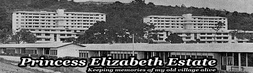
Sadly, the estate that was built in 1951 as a gift to Princess Elizabeth on her wedding to Prince Philip, was totally demolished by 1995.
Princess Elizabeth Estate was located at the then 9-1/4 milestone (14km) Upper Bukit Timah Road. The only access from Upper Bukit Road was a small road called Princess Elizabeth Estate Drive. Today this same road exists and is simply called Elizabeth Drive.

 |
| Maps courtesy of Lam Chun See See his blog at Good Morning Yesterday |
 |
| P.E.Estate has been taken off today's maps. |
Popular Estate and Bamboo Grove Park were built in the late 1960s on the hillside west of P.E.Estate. The adjoining Hillview Estate was built by the HDB around 1980. A Chinese kampong was located at the Lorong Taluki / Lorong Seburut area, where the current Mindef lies.
Pioneer factories operating there at the time were Ford Motors, Hume Pipes, Gammon, Malayan Guttas, Malayan Spinning Mills, Kiwi, National Carbon (Union Carbide) and Dairy Farm.
The most prominent factory then at the estate was Union Carbide. To direct taxi drivers to locate P.E.E., you would tell them to go to 'Tien Tor Long", in Hokkien - "the battery factory".
After Singapore's Independence, the Hillview area was identified for light industrial manufacturing and more factories were set up along Hillview Ave such as Castrol, Cerebos, Yakult, Lam Soon Oil and Cycle & Carriage. Today all these factories have been relocated and replaced by condominiums.

Princess Elizabeth Estate had a unique addressing system.
Before 1965, there were no block numbers. Each house was numbered serially from No.1 to No. 142. Units on the upper floors were suffixed with A-B-C-D-E-F, representing the 2nd to 7th floor.
So a letter addressed to 126A Princess Anne Hill or just as 126A Princess Elizabeth Estate would be delivered correctly. The Estate was in District 23, making the postal code Singapore 23.
In 1965, Singapore Postal Service standardized the house numbering system.
This resulted in all the blocks getting a Block Number as well as a floor number from #01- #07.
The postal code was later expanded to 2365 and eventually in 1995 changed to the 6-digit 650xxx format.
There was in fact only 1 paved road within the estate called Elizabeth Drive. The other street names were not 'roads' but basically footpaths leading to the various blocks. These were Princess Anne Hill, Prince Charles Rise, Clarence Walk and Philip Walk.
I've personally witnessed the demolition of Blk23/24 around 1996. I still remember a tall crawler crane with a huge wrecking ball was used. Back then i was just 6 years old, a kid in kindergarten at Bukit Gombak CC, staring at a crane hammering its steel ball at the hi-rise flat.
ReplyDeleteI still remember the ball came down, crashing into the flat, and a leathered sofa fell out from around 10 storeys or so and crashed to the ground. Back then i didnt know it was Princess Elizabeth Estate. But after looking at the main pic of your blog, now it makes sense it should be either Blk23 or 24